How To Do IELTS Academic Writing Task 1 Maps
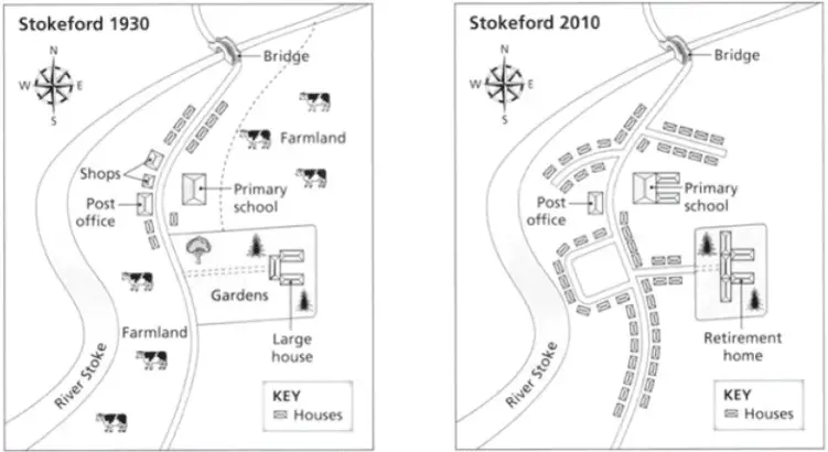
The maps below show the village of Stokeford in 1930 and 2010.
Summarise the information by selecting and reporting the main features, and make comparisons where relevant.
MODEL ANSWER
The maps illustrate the settlement of Stokeford in 1930 and 2010 revealing what has changed and what has remained the same.
Overall, the biggest difference is the number of houses that have been built along the main road and on new side roads, much of this on farmland. The large house has been converted into a retirement home and the primary school has also been extended.
Originally, there were as few as ten houses standing on the main road, however in 2010 there were approximately fifty houses in total. Some of these houses were built on one of the four new side roads extending off to both the east and west sides of the main road and were built on farmland.
In 1930, the large house consisted of three buildings positioned in a horseshoe shape. By 2010 two further buildings had been added to either side of the horseshoe and the original gardens had been converted into building land. The primary school has been extended at the rear of the property and the shops previously opposite the school have been demolished although the post office has remained. (185 words)
Teaching Points: Notice that there are four different tenses being used in this summary. IELTS maps that show changes over time provide a great opportunity for you to show the examiner how good your control of different tenses is. Can you identify the different tenses being used in this example?
IELTS Writing Task 1 (Academic)
Discover how to describe all types of visual data that you may see in this part of the test.

Sshhhhh! Listen closely, here are some valuable tips, techniques and strategies for maximising your listening band score.

IELTS Writing Task 1 (General)
Discover how to write in the correct format and tone for this part of the test.

Learn 'what' to say and 'how' to say it in each part of the test to impress the examiner.